You can construct your own drawing using WGT tools, but it's tedious.
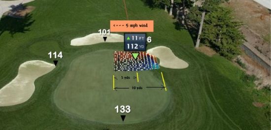
On any of the greens, use the forward (and reverse, if available) green view camera. select pitch or chip shot mode, and click on the desired area of the green. it will show a contour grid square (10 yds x 10 yds) with the grid lines 2 ft apart.

Use the right-click/Zoom in feature if the grid is too small to see 'rolling dots'. The aiming point has the relative elevation at the center of the grid, so by dragging the aiming point around the green you can determine the large-scale (1 foot or more) elevation changes, along with any local low points, mounds, ridges and valleys.
Note that as long as any part of the grid touches the green, the entire contour is show, thus you can also map everything within 8 or 10 yards of the green. Remember that black lines indicate flat terrain at target elevation, red is below that grade, blue is above, lite blue is steep up, orange/yellow is steep down.
As a matter of fact I'm in the process right now of doing that for the front nine at Pinehurst, which will be available for full play in May. You won't regret the effort, and playing the Open CTTH tourney is an easy path to the views you need right now.